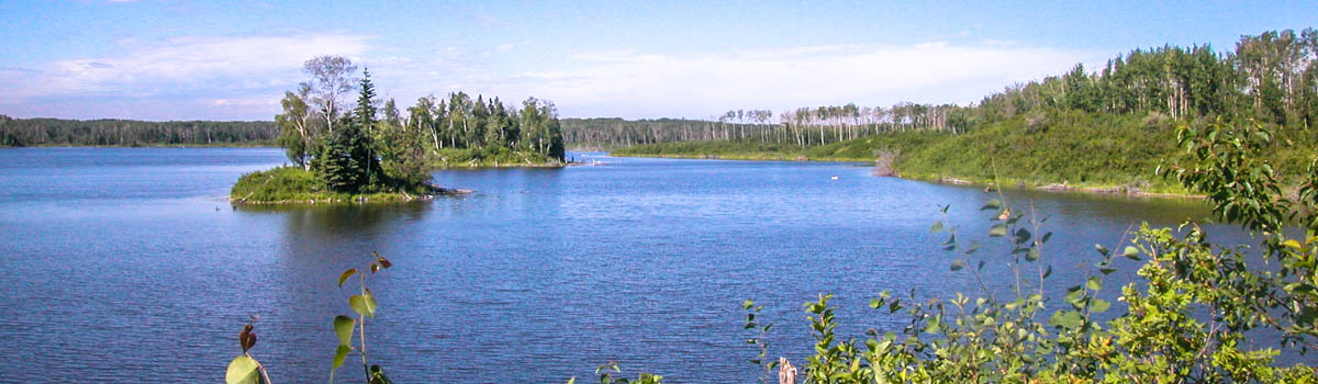
The trails at Cooking Lake-Blackfoot total approximately 170 km in length and provide recreational opportunities to a multitude of users. From cross country skiing, snowshoeing and dog sledding in the winter season to hiking, mountain biking and equestrian use in the summer, these trails provide ample opportunity to experience nature first-hand. Weave through forests of spruce, poplar and birch while taking in stunning views of waterfowl-filled wetlands.
Maintaining the trail system is a big job and Parks staff work hard to ensure every user has the opportunity to enjoy their time on the trails. As such, these trails are divided into prioritized sections in the winter season, or zones, to allow for timely and effective mowing, fallen tree removal, snow grooming and track-setting. These zones have been determined based on trail use and demand and weather trends. Priority Zone 1 trails are often maintained first, followed by Zone 2, 3, and 4 respectively.
Select the Priority Zone tab below the map to check the status of those trails.
During the summer, you can view the trail sections by staging area.
Please note, distances on map may vary slightly from the trail report table. Please refer to the trail report table for most accurate distances.
Maps: | |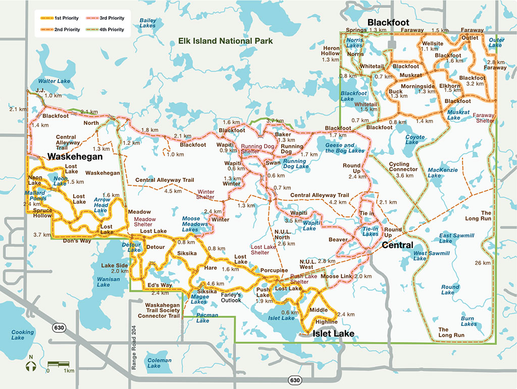
Updated: June 16, 2025 |
Please leave all gates how you find them. Cattle are in the fields, some gates may be locked while cattle are being moved.
Trail maintenace has resumed. Please obey all signage
CLOSURES:
JJ TRAIL - Flooded
WAPITI TRAIL (north portion) - Flooded
General Information:
Winter Information:
| Trail | Summer | Winter | Length | Status |
|---|---|---|---|---|
|
Baker Springs |
  
|

|
1.2 km | Open |
|
Blackfoot West (from Waskehegan Staging to Round Up trail) Northwest corner of Blackfoot trail (known as J.J. trail) is closed due to beaver activity, flooding and major damage to bridge. Impassible. NOW Open to Wagons and Sleighs
|
|
|
13.6 km | Partially Closed |
|
Boundary |
|
|
2.0 km | Open |
|
Central Alleyway |

|
 
|
15.2 km | Open |
|
Cutoff Trail is Single Track, and not mowed in the summer months. |
|
|
0.4 km | Open |
|
Detour |
|

|
2.1 km | Open |
|
Don's Way |
|
|
3.2 km | Open |
|
Ed's Way |
|
|
2.0 km | Open |
|
Flattail |
|
|
0.4 km | Open |
|
Grouse |
|
|
1.2 km | Open |
|
Hare |
|
|
0.9 km | Open |
|
J.J. Closed due to beaver activity and flooding. Bridge is off its foundation. Sections impassible. |
|
|
1.3 km | Closed |
|
Lost Lake Maintenance to occur on portions of trail, please obey all signage. |
|
|
14.9 km | Partially Closed |
|
Meadow |
|
|
0.8 km | Open |
|
Neon Lake |
|
|
1.8 km | Open |
|
North |
|
|
3.5 km | Open |
|
Running Dog |
|
|
3.0 km | Open |
|
Spruce Hollow |
|
|
2.7 km | Open |
|
Swan |
|
|
0.5 km | Open |
|
Wanisan |
|
|
4.0 km | Open |
|
Wapiti North (from Winter to Blackfoot trail) Trail from Blackfoot trail intersection to Running Dog intersection is flooded |
|
|
1.6 km | Partially Closed |
|
Waskehegan North (from Central Alleyway to Blackfoot Trail) |
|
|
1.2 km | Open |
|
Waskehegan South (Central Alleyway to Lost Lake Trail) |
|
|
1.8 km | Open |
|
Winter North (from Central Alleyway to Wapiti trail) |
|
|
1.2 Km | Good |
|
Winter South (from Lost Lake trail to Central Alleyway) |
|
|
2.4 km | Open |
Updated: June 27, 2025 |
Please be advised RR 200 is open to local traffic only - Park remains open
Please leave all gates how you find them. Cattle are in the fields, some gates may be locked while cattle are being moved.
Trail maintenace has resumed. Please obey all signage
CLOSURES:
JJ TRAIL - Flooded
WAPITI TRAIL (north portion) - Flooded
General Information:
Winter Information:
| Trail | Summer | Winter | Length | Status |
|---|---|---|---|---|
|
Highline |
|
|
3.1 km | Open |
|
Lost Lake Maintenance to occur on portions of trail, please obey all signage. |
|
|
14.9 km | Partially Closed |
|
Middle |
|
|
1.3 km | Open |
|
Moose Link |
|
|
2.4 km | Open |
|
Porcupine |
|
|
0.5 km | Open |
|
Push Lake |
|
|
1.9 km | Open |
|
Siksika Maintenance from the intersections of Hare to Porcupine please obey signage |
|
|
5.8 km | Partially Closed |
|
Winter South (from Lost Lake trail to Central Alleyway) |
|
|
2.4 km | Open |
Updated: June 27, 2025 |
Please be advised RR 200 is open to local traffic only - Park remains open
Please leave all gates how you find them. Cattle are in the fields, some gates may be locked while cattle are being moved.
Trail maintenace has resumed. Please obey all signage
CLOSURES:
The BLACKFOOT staging area is CLOSED seasonally to all equestrian use from December 1- March 31
JJ TRAIL - Flooded
WAPITI TRAIL (north portion) - Flooded
General Information:
Winter Information:
| Trail | Summer | Winter | Length | Status |
|---|---|---|---|---|
|
Baker Springs |
|
|
1.2 km | Open |
|
Beaver |
|
|
3.3 km | Open |
|
Central Alleyway |
|
|
15.2 km | Open |
|
Cutoff Trail is Single Track, and not mowed in the summer months. |
|
|
0.4 km | Open |
|
Long Run Winter Trail Only - will update once groomed or check Nordic Pulse for live updates
|
|
  
|
26 Km | Closed |
|
Round Up |
|
|
5.2 km | Open |
|
Running Dog |
|
|
3.0 km | Open |
|
Swan |
|
|
0.5 km | Open |
|
Tie-In |
|
|
1.0 km | Open |
|
Wapiti South (from Central to Winter trail) |
|
|
6.5 km | Open |
Updated: June 27, 2025 |
Please leave all gates how you find them. Cattle are in the fields, some gates may be locked while cattle are being moved.
Trail maintenace has resumed. Please obey all signage
CLOSURES:
JJ TRAIL - Flooded
WAPITI TRAIL (north portion) - Flooded
OTHER NOTES:
Lamont County has restricted traffic to 50% capacity along the main access road - range road 195 - from HWY 16 south to Blackfoot Staging Area. County ban information can be found HERE.
General Information:
Winter Information:
| Trail | Summer | Winter | Length | Status |
|---|---|---|---|---|
|
Blackfoot East (from Blackfoot Lake Staging to Round Up trail) |
|
|
11.2 Km | Open |
|
Buck Run |
|
|
2.0 km | Open |
|
Central Alleyway |
|
|
15.2 km | Open |
|
Elkhorn |
|
|
1.6 km | Open |
|
Faraway East |
|
|
6.2 km | Open |
|
Faraway West |
|
|
1.3 Km | Open |
|
Gas Line Winter Use Trail Only - under water in summer Skate Skiing, Dog Sledding, Fat Tire Biking |
|
|
0.3 km | Open |
|
Heron Hollow |
|
|
2.5 km | Open |
|
Long Run Winter Trail Only - will update once groomed or check Nordic Pulse for live updates
|
|
|
26 Km | Closed |
|
Morningside |
|
|
2.1 km | Open |
|
Muskrat |
|
|
1.1 km | Open |
|
Norris Ridge |
|
|
1.5 km | Open |
|
Outlet |
|
|
0.3 km | Open |
|
Springs Bridge is out along the fence line towards Norris Ridge intersection |
|
|
2.0 km | Partially Closed |
|
Wellsite |
|
|
1.1 km | Closed |
|
Whitetail |
|
|
3.1 km | Open |