Kananaskis Country is committed to providing diverse, enjoyable outdoor recreation opportunities that contribute to
- Healthy lifestyles while conserving the natural heritage of the region and
- Long-term sustainability of ecosystems and biodiversity for the benefit of current and future generations
These goals helped guide decision-making in identifying trails approved and recognized for fat biking (listed below).
Fat Biking Etiquette on Approved Groomed Trails
- Bikes yield to all other users.
- Recommended tire size is 3.8 inches or wider. Tire pressure should be 8 psi or lower and adjusted for conditions.
- Do not ride if your tires are leaving a rut or if you’re having difficulty riding in a straight line.
- On multi-use trails, do not ride in or over the cross-country ski tracks and avoid mixing dirt into the snow.
- If riding on shared snowmobile trails, wear flashing lights and reflective equipment.
- Be an ambassador for the sport. Be polite, educate other riders and discourage bad behaviour.
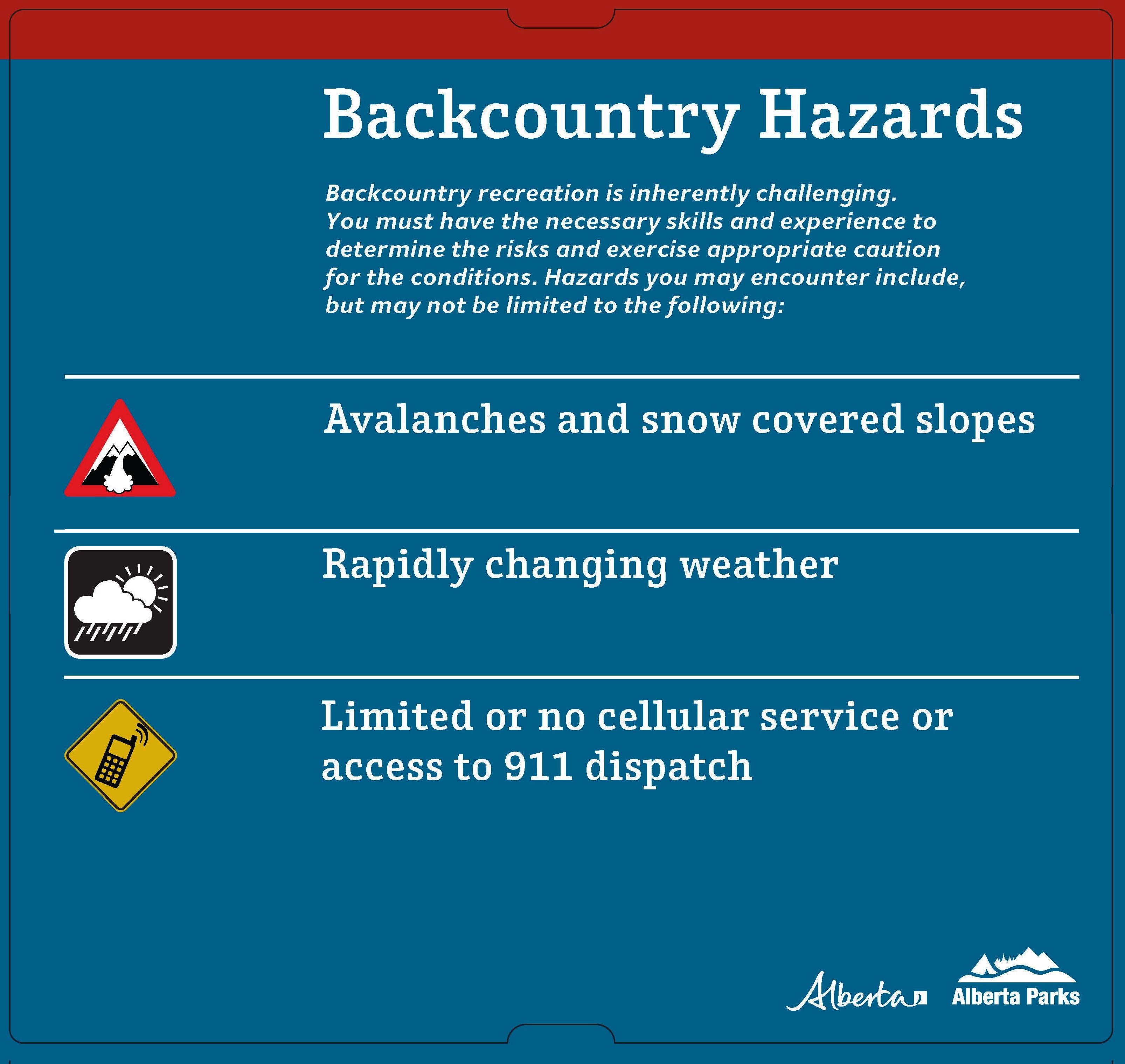
Backcountry Safety
Approved Fat Biking Trails
Canmore and Area: Trail Report
- Highline Trail (Note: Potential avalanche hazard at drainages)
- Meander Trail
- Montane Traverse Trail
- Johnny's
- Horseshoe Loop
Canmore Nordic Centre: More Info
Fat biking at the Canmore Nordic Centre is only permitted on designated single track trails marked with fat bike signage
- EKG East*
- EKG
- Blue Coal Chutes
- Long Road to Ruin
- Orchid
- Odyssey
- FYI
- Rundle Connector
*A
wildlife corridor exists in the portion of
Bow Valley Wildland Provincial Park located above the stadium area at Canmore Nordic Centre Provincial Park. Each year, travel in this area is
- Prohibited from December 1 to June 15 (including all trails above EKG East - Killer Bees, Ziggy’s, Nectar Noodle, The Backdoor, The Albertan)
- Restricted to designated trails only from June 16 to November 30
Spray Valley Provincial Park: Trail Report
- Watridge Lake (To Watridge Lake only; excludes section past Watridge Lake towards Banff National Park)
- High Rockies (Note: Between Nov. 1 and May 1 the trail is closed through the Buller Slide Path due to Highway Avalanche Control.)
Peter Lougheed Provincial Park: Trail Report
- Canyon Snowshoe
- Penstock Loop Snowshoe
- Lower Lake Snowshoe
- Marsh Loop Snowshoe
- Elkwood Loop Snowshoe
- Elk Pass Snowshoe
- Wintour Snowshoe
- Hogarth Lakes Snowshoe
- Frost Heave Snowshoe
- Graupel Snowshoe
- Snowdrift Snowshoe
- Sawmill Loop Snowshoe
- South Sawmill Loop Snowshoe
- Tailwater Snowshoe
- Frozen Toad Snowshoe
- Torpor Loop Snowshoe
Kananaskis Valley (Evan-Thomas Provincial Recreation Area): Trail Report
- Bill Milne Paved Trail (Kananaskis Village to Wedge Pond)
- Evan Thomas Fire Road (to Wedge Connector)
- Wedge Connector
- Ribbon Creek Snowshoe Trail
- Village Snowshoe Loop
- Aspen Terrace Short Loop
- Aspen Terrance Long Loop
- Mine Meadow
- Shinrin
- Studless
- Stoney Trail (Seasonal closure: April 15-June 15)
- Troll Falls Trail
- Coal Mine
- Portion of Centennial Trail between below Coal Mine
Sibbald Flats (Sibbald Area/Baldy Pass PRA/Kananaskis PLUZ)
Trail Report (Jumpingpound Loop, Lusk Pass, Tom Snow), Trail Report (Baldy Pass)
- Baldy Pass Trail (Note: Potential avalanche hazards on NE slope)
- Jumpingpound Loop Trail
- Lusk Pass Trail
- Tom Snow
- Moose Creek Loop
Elbow Valley: Trail Report
- Diamond T Loop Trail
- Elbow Valley Trail
- Powderface Creek Trail
- Prairie Creek Trail
- Prairie Link Trail
- Sulphur Springs Trail
West Bragg Creek: Trail Report
- Bobcat Trail
- Boundary Ridge Trail
- Braggin Rights Trail
- Crystal Line Winter Multi-use
- Demi-Tel Trail
- Disconnect Trail
- Elbow Trail (Allen Bill Day Use to Snagmore Trail ONLY)
- Long Distance Trail
- Merlin View Trail
- Mountain Road
- Old Shell Road
- Ranger Summit Trail
- Reconnect Trail
- Ridgeback Trail (Between Diamond T and Bobcat)
- Snagmore Trail
- Snakes and Ladders Trail
- Snowshoe Hare Trail (West of Telephone Loop East Trail ONLY)
- Snowy Owl
- Snowy Shortcut
- Sugar Daddy
- Sugar Momma
- Strange Brew Trail
- Telephone Loop
- Whitetail
Sandy McNabb (Sheep Valley): Trail Report
- Death Valley Trail (Does NOT include Death Valley Loop)
- Long Prairie Ridge Trail
- Sheep River Road to Bighorn Lookout