Castle Provincial Park

Alberta Parks

Castle River Bridge Campground

Information: 1-877-537-2757
Directions
Ice Safety: Alberta Parks does not monitor ice conditions; learn how to assess them for yourself.

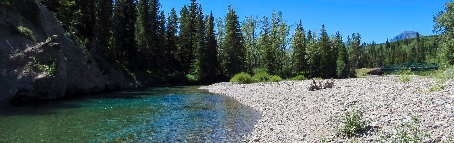
This campground is along the Castle River in Castle Provincial Park. It is 20 km west of Pincher Creek on Hwy. 507, 16 km south on Hwy. 774 and 1 km west on an access road. Sites are suited to tents and RVs and are located along the river. Here you can fish or hike, and paddlers with advanced moving water experience can play on the river.

Camping

Season: May 16 - Sep 28
Site Type Campsites Power Rate/Night Reservable Dates Current Status
Power 25 / 30 $34 May 16 - Sep 28 Seasonal Closure

  • Reservations can be made 90 days in advance of arrival date.

Opening dates are subject to weather conditions.

All campsites are 100% reserveable

When camping in a powered site:

  • use 1-2 electrical appliances maximum at the same time. When campers lose power, it's usually because too much electricity is being used at once.
  • Do not use adapters to draw power from a 15 amp for an RV with a 30 amp plug.
  • Have a backup plan. Use other methods to cook, stay cool/warm and keep entertained.

Remember, conserving electricity and timing when you use your electricity in a campsite will ensure you can stay powered. Get more information about using power sites.

Amenities


Bookings Open
February 15 True

Firewood
  • Firewood alert! Firewood not available. Help stop the spread of forest pests, Dutch elm disease and emerald ash borer. Plan to buy firewood locally, burn on site, never bring home.


Water

Potable water is available at standpipes throughout the campground.

Accessibility

Wheelchair Accessible Washrooms.

Learn about Accessible Camping in Alberta Parks

    Maps & Guides

    • Bird Checklist birding. checklist, Castle Parks, Castle PP, Castle WPP, Publications Beaver Mines Lake Campground Castle Falls Campground Castle River Bridge Campground Lynx Creek Campground Designated Camping Areas 1 Campground Designated Camping Areas 2 Campground Designated Camping Areas 3 Campground Designated Camping Areas 4 Campground Designated Camping Areas 5 Campground Designated Camping Areas 6 Campground Designated Camping Areas 7 Campground Designated Equestrian Camping Area Campground Beaver Mines Boat Launch Day Use Beaver Mines Entrance Staging Day Use Beaver Mines Forest Day Use Beaver Mines Lakeview Day Use Carbondale Staging Day Use Castle Falls Day Use Castle River Bridge Day Use Lynx Creek Day Use Syncline North Day Use Syncline South Day Use Table Mountain Staging Day Use Gladstone Creek Day Use Syncline Barnaby Staging Day Use Syncline A Group Use Syncline B Group Use Beaver Mines Lake Cabins CC Castle River Bridge Cabins CC -- 31026 False
    • Campgrounds Map Castle PP, map, Beaver Mines Lake Campground, Beaver Mines Boat Launch Day Use, Beaver Mines Entrance Staging Day Use, Beaver Mines Forest Day Use, Beaver Mines Lakeview Day Use, Castle Falls Campground, Castle River Bridge Campground, Lynx Creek Campground, Syncline A Group Use, Syncline B Group Use, Table Mountain Staging Day Use, Great Divide Trail -- 31026 False
    • Designated Camping Areas (DCAs) Map Castle PP, map, Beaver Mines Lake Campground, Beaver Mines Boat Launch Day Use, Beaver Mines Entrance Staging Day Use, Beaver Mines Forest Day Use, Beaver Mines Lakeview Day Use, Castle Falls Campground, Castle River Bridge Campground, Lynx Creek Campground, Syncline A Group Use, Syncline B Group Use, Table Mountain Staging Day Use, Great Divide Trail -- 31026 False
    • Castle Summer Park Guide Castle PP, Castle WPP, Random Camping, Backcountry Camping, Mount Ptolemy, Great Divide Trail North, Syncline Trail Network, Andy Good Base, Designated Camping Areas Equestrian, Castle PP Beaver Mines Lake Campground Castle Falls Campground Castle River Bridge Campground Lynx Creek Campground Designated Camping Areas 1 Campground Designated Camping Areas 2 Campground Designated Camping Areas 3 Campground Designated Camping Areas 4 Campground Designated Camping Areas 5 Campground Designated Camping Areas 6 Campground Designated Camping Areas 7 Campground Designated Equestrian Camping Area Campground Beaver Mines Boat Launch Day Use Beaver Mines Entrance Staging Day Use Beaver Mines Forest Day Use Beaver Mines Lakeview Day Use Carbondale Staging Day Use Castle Falls Day Use Castle River Bridge Day Use Lynx Creek Day Use Syncline North Day Use Syncline South Day Use Table Mountain Staging Day Use Gladstone Creek Day Use Syncline Barnaby Staging Day Use Syncline A Group Use Syncline B Group Use Beaver Mines Lake Cabins CC Castle River Bridge Cabins CC -- 31026 False
    • Castle Summer Trail Map Georeferenced Map, Castle PP, Designated Summer Trails Map 2018, Castle WPP Campground: Beaver Mines Lake, Castle Falls, Castle River Bridge, Lynx Creek, Comfort Camping: Beaver Mines Lake Cabins Day Use: Beaver Mines Boat Launch, Beaver Mines Entrance Staging, Beaver Mines Forest, Beaver Mines Lakeview, Carbondale Staging, Castle Falls, Castle River Bridge, Lynx Creek, Syncline North, Syncline South, Table Mountain Staging, Gladstone Creek, Group Use: Syncline A, Syncline B, Designated Camping Areas Equestrian, Castle PP Trails: Andy Good Base Barnaby and Southfork Lake Beaver Mines Interpretive Trail Bovin (Blue) Lake Gardiner Creek/ Great Divide Connector Great Divide Trail North Grizzly and Ruby Lakes Middle Kootenay Pass Middle Kootenay Pass North Drywood Falls North Kootenay Pass North Lost Creek North York Creek/ Plane Crash Table Mountain -- 31026 False
    • Castle Winter Trails Map Georeferenced Map, Castle PP, Designated Winter Trails Map, Castle WPP Campground: Beaver Mines Lake, Castle Falls, Castle River Bridge, Lynx Creek, Comfort Camping: Beaver Mines Lake Cabins Day Use: Beaver Mines Boat Launch, Beaver Mines Entrance Staging, Beaver Mines Forest, Beaver Mines Lakeview, Carbondale Staging, Castle Falls, Castle River Bridge, Lynx Creek, Syncline North, Syncline South, Table Mountain Staging, Gladstone Creek Group Use: Syncline A, Syncline B Trails: Andy Good Base Barnaby and Southfork Lake Beaver Mines Interpretive Trail Bovin (Blue) Lake Gardiner Creek/ Great Divide Connector Great Divide Trail North Grizzly and Ruby Lakes Middle Kootenay Pass Middle Kootenay Pass North Drywood Falls North Kootenay Pass North Lost Creek North York Creek/ Plane Crash Table Mountain -- 31026 False
    • Equestrian Guide Castle Wildland and Provincial Parks Castle PP, Castle WPP, Random Camping, Backcountry Camping, Mount Ptolemy, Great Divide Trail North, Syncline Trail Network, Andy Good Base, Designated Equestrian Camping Area Campground, Beaver Mines Lake Campground Castle Falls Campground Castle River Bridge Campground Lynx Creek Campground Designated Camping Areas 1 Campground Designated Camping Areas 2 Campground Designated Camping Areas 3 Campground Designated Camping Areas 4 Campground Designated Camping Areas 5 Campground Designated Camping Areas 6 Campground Designated Camping Areas 7 Campground Designated Equestrian Camping Area Campground Beaver Mines Boat Launch Day Use Beaver Mines Entrance Staging Day Use Beaver Mines Forest Day Use Beaver Mines Lakeview Day Use Carbondale Staging Day Use Castle Falls Day Use Castle River Bridge Day Use Lynx Creek Day Use Syncline North Day Use Syncline South Day Use Table Mountain Staging Day Use Gladstone Creek Day Use Syncline Barnaby Staging Day Use Syncline A Group Use Syncline B Group Use Beaver Mines Lake Cabins CC Castle River Bridge Cabins CC -- 31026 False
    • Regulations
    • Safe Boating Guide
    • Bear Smart
    • Living With Cougars


Updated: Nov 28, 2024