Upland systems include a variety of landscapes that originated from sediments associated with glaciation or are characterized by thick deposits of coarse sand.
This includes sandy and non-sandy moraines, lake deposits, as well as dune fields, kames and outwash plains.
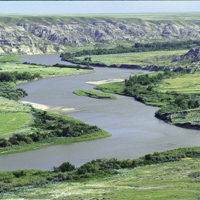
Valley/Ridge systems include a variety of landscapes that are made up of valley slopes, ridge tops, valley floors, flood plains, river channels and river terraces.
Bedrock
Outcrops of consolidated rock
This theme is mapped primarily in northeastern Alberta (igneous and conglomerate, sandstone, siltstone, and shale) and in the Rocky Mountains (clastic rocks, limestone, and dolostone), with minor exposures on the plains (clastic rocks).
Although it is considered part of Upland Systems in most of the province, it is considered part of Valley/Ridge Systems where it occurs in the Rocky Mountains and Foothills Natural Regions.
Colluvial Deposits
Materials that have reached their present position as a result of direct, gravity-induced movement
These commonly occur as slope and slump deposits confined to valley sides and floors. They often include bedrock and surficial materials and may be vegetated or exposed slopes. Badlands are typically included.
These include a significant component of fluvial deposits in places, as these two units are inseparable at this scale.
Eolian Deposits
Wind-deposited sediments comprising well-sorted sands and minor silt
This theme includes both active and vegetated dunes, blowout and remnant sand dune ridges, and fairly level sand plains.
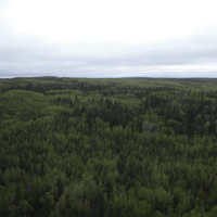
Fluted Moraine
Streamlined glacial terrain shaped by erosion, deposition and squeezing of sediment beneath moving glacial ice
The terrain, which is composed mainly of till, varies from alternating furrows and ridges to elongated smoothed hills which parallel the likely ice-flow direction. It includes features such as flutes, drumlins and drumlinoids.
Fluvial Deposits
Sediments deposited by streams and rivers that include poorly to well sorted, layered to un-layered sand, gravel, silt, clay, and organic sediments occurring in channel and overbank or floodplain deposits
These include a significant component of colluvial deposits In places, as these two units are inseparable at this scale.
Glaciofluvial Deposits
Sediments deposited by glacial meltwater in contact with or near a glacier
These are generally a flat to gently undulating plain which may be marked by meltwater channel scars and kettle holes or have features like slumped structures that show evidence of ice melting.
They occur as part of the Valley/Ridge Systems in the Rocky Mountains and Foothills Natural Regions.
Glaciolacustrine Deposits
Sediments deposited in or along the margins of glacial lakes often reworked by wave action including
Offshore sediment composed of deposits of fine sand, silt and clay, locally containing debris released by melting of floating ice
Nearshore (littoral) sediments of well-sorted silty sand, pebbly sand and minor gravel that have sometimes been deposited as distinct layers
These are commonly a flat to gently rolling plain but often include irregular hummocks, circular hummocks with a central depression, plainnteau mounds and/or ridges, beaches, bars and deltas/spits.
Photo Credit: Mark Fenton
Ice-Thrust Moraine
Bedrock, till and water-sorted materials that have been carried by ice as a more or less intact entity or block but that have been folded and pushed by glacial pressure
The blocks of bedrock are often thrust over one another on shear planes like shingles.
The resulting terrain is generally high- to moderate-relief, and includes ice-thrust moraine ridges, hill-hole pairs, rubble moraine and thrust-block moraine.
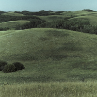
Moraine
Terrain composed of very poorly sorted or unsorted sediments (till) deposited directly by glacial ice
This is usually made up of a mixture of clay, silt, and sand, as well as minor pebbles, cobbles, and boulders and characterized by a lack of distinctive topography.
Locally, this unit may contain blocks of bedrock, layered sediments or lenses of glaciolacustrine and/or glaciofluvial sediment.
These occur as part of the Valley/Ridge Systems in the Rocky Mountains and Foothills Natural Regions.
Stagnant Ice Moraine
Terrain resulting from the collapse and slumping of debris that was trapped inside glacial ice, or that had collected on top of a glacier as the buried glacial ice melted
Sediment is mainly till but locally includes layered glaciolacustrine or glaciofluvial sediments.
Terrain is characterized by low- to high-relief hummocky topography and features include end and recessional moraines, as well as crevasse fillings.
Freshwater Systems
Freshwater habitats that include both still water (lentic) and running water (lotic) systems
These systems are associated with water-altered soils, the growth of water-tolerant to water-loving vegetation and biological processes of a wet environment.
These include wetlands, lakes and rivers with their associated riparian vegetation, as well as modern glaciers.
Organic Wetlands
Wetlands with significant peat accumulation (around or more than 40cm of poorly decomposed plant material predominantly from moss or sedge) and relatively stable water levels
In the Boreal Forest Natural Region, this unit also includes organic deposits of undifferentiated peat (woody to fibrous muck) and, at this scale, may include areas at the edge of wetlands or areas that may not easily be recognizable as a classic wetland.
This unit is commonly underlain by fine-grained, poorly drained glaciolacustrine or lacustrine deposits or by till in some places.
This theme includes swamps, bogs and fens.
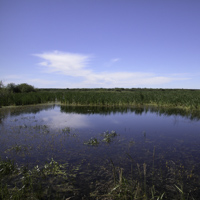
Mineral Wetlands
Wetlands with mineral or mixed mineral and organic soils with minimal peat accumulation
Water levels may fluctuate.
This includes marshes and shallow open water vegetation, and sometimes has woody vegetation in northern Alberta.
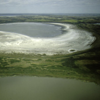
Alkali Wetlands
Wetlands with minimal or no peat accumulation, with high levels of salinity or alkalinity (more than 3ppm), dominated by vegetation that thrives in saline environments (halophytic)
They tend to remain free of ice cover longer than freshwater wetlands.
These may become dry alkali flats, playas or dry lake basins later in the summer or during drought years.
Lake
Any naturally occurring, sizeable, permanent, relatively deep body of water, whether fresh or alkaline with well-defined beds and banks
Man-made reservoirs are excluded from this theme.
Major River
A large, natural and perennial flow of water that follows a definite course or channel or series of diverging and converging channels
At this scale, only major river systems associated with fluvial deposits are included. Smaller and intermittent streams are included under the Upland and Valley/Ridge Systems.
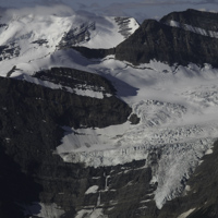
Modern Glaciers
Permanent snow and ice (mapped from data circa 1994); includes icefields, valley and cirque glaciers
This unit occurs only the Alpine Subregion of the Rocky Mountains Natural Region.
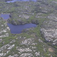


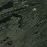
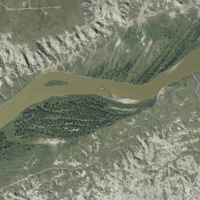
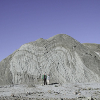 Photo Credit: Mark Fenton